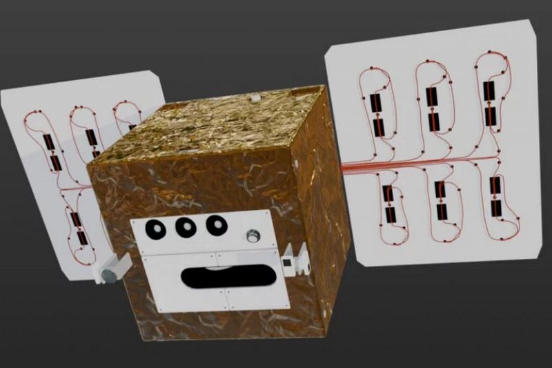
High-precision sensor technology – data that shapes the future

The heart of DIEGOSat beats in the form of a unique, multispectral sensor system that has been specially developed for maximum precision and versatility. With its combination of long-wave and mid-infrared bands, it not only provides temperature measurements, but also opens up a wide range of applications – from detecting the smallest fires to analyzing plant stress and observing urban heat islands. The DIEGOSat sensors are being developed by medium-sized German space companies, based not least on the extensive scientific and technical know-how gained in previous sensor developments for the German missions BIRD, FireBIRD, and EnMAP. With their high sensitivity and excellent spatial resolution, the sensors provide freely accessible scientific data with high precision for a large number of users in many areas of business and society. The free availability of DIEGOSat data is an important basis for sustainable decisions on how to treat our environment.


Technology that sets standards

At the heart of DIEGOSat is a high-resolution, cooled infrared sensor system based on two cooled cadmium mercury telluride (CMT) matrix detectors, which are optimally dimensioned and operated for their respective wavelength ranges in the mid- and thermal infrared. This technology enables extremely precise temperature measurements with an accuracy of < 0.5 K – significantly better than comparable systems.

Wide range for many applications

The sensor technology covers several wavelength ranges:

  • 5 bands in the longwave infrared (LWIR, 8-12 µm) for measuring land and sea surface temperatures and emissivity, as well as for investigating urban heat islands and drought stress in agriculture and forestry.
  • 2 bands in the mid-infrared (MWIR, 3,5–5 µm), optimized for the detection and quantification of high-temperature events such as fires or industrial gas flares.
  • 3 bands in the visible range of light and near-infrared (VNIR) with high resolution, ideal for vegetation analysis.


See more – at any time of day

The inclined orbit, similar to that of the International Space Station (ISS), enables observations at different times of day, which is crucial for analyzing the variability of temperature, evaporation, and fire activity. The VNIR technology is optimized to enable even nighttime imaging, e.g., for studying light pollution.

Combination of VNIR, MWIR, and LWIR

The simultaneous acquisition of data in the visible light range and infrared (VNIR) up to thermal infrared (MWIR, LWIR) allows for precise determination of emissivity. This not only enables temperatures to be measured, but also allows conclusions to be drawn about the condition of vegetation, soil, or water.

Innovation from Germany

The sensor technology and readout electronics combine patents and developments from leading German aerospace companies, including AIM Infrared Modules, POG Precision Optics Gera, Kampf Telescope Optics from Hoerner & Sulger, and Astro- und Feinwerktechnik Adlershof. The combination of precision, sensitivity, and versatility makes the system unique in international comparison.